Crossing Three Rivers: A 2,300-Kilometer Self-Driving Epic Through the Hengduan Mountains
Crossing Three Rivers: A 2,300-Kilometer Self-Driving Epic Through the Hengduan Mountains
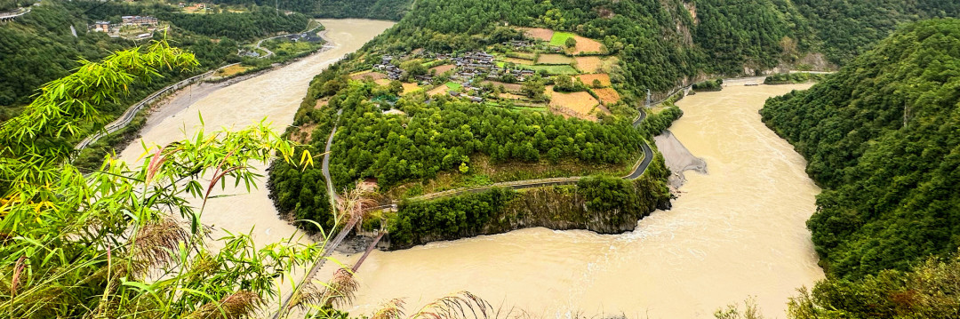
From the Yunnan-Guizhou Plateau to the edge of the Qinghai-Tibet Plateau, three great rivers—the Nujiang (Salween), Lancangjiang (Mekong), and Jinshajiang (upper Yangtze)—surge side by side deep within the Hengduan Mountains, carving out the most spectacular canyon complex on Earth. This is a self-driving journey of approximately 2,300 kilometers, dominated by winding mountain roads with occasional stretches of expressway—and the National Day holiday's toll-free policy made the trip feel especially generous. Even more pleasantly surprising, accommodation along the way was not expensive, with comfortable lodgings available for 100 to 300 yuan per night.
Departure: Heading West from Kunming Airport
First Night: A Brief Rest Near the Airport
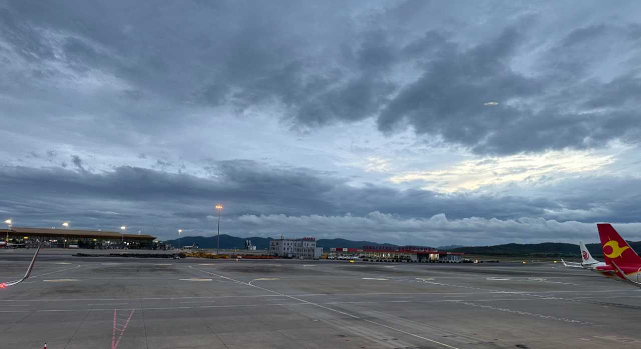
Arriving at Kunming Changshui Airport in the evening, the airport restaurant felt desolate and lonely. A bowl of noodles was priced at 100 yuan, killing any appetite. The only comforts on the plane were music, a small packet of peanut-coated fish crackers, and 200 milliliters of mineral water—the brand was called "Grace," but the grace was miserly. After a stopover in Yueyang, the plane flew toward Kunming. Through the window, the golden light of sunset merged floating clouds with the mountains, a breathtakingly beautiful scene. Unfortunately, I hadn't chosen a window seat, so I could only hastily film a poorly angled video.
The hotel I checked into was right next to the airport, a half-hour walk away. Considering I had already traveled by high-speed rail, subway, and plane that day, I decided to drag my two suitcases over on foot. Above the hotel, planes roared past in landing mode—this was an arrival, but also the beginning of a new journey. To the west, beneath the clouds, the lights of Kunming city glowed.
Picking Up the Car and the First Stretch of Road

Early in the morning, I picked up the car at the "Cheyou Tianxia" (Car Travel the World) rental point right next to the hotel. These days, there are many rental companies, closely cooperating with various platforms—no longer relying on just a few large firms like in the past. After loading the luggage, I checked the navigation: from Kunming to Yongping, there were three routes. One section of the Kunming-Chuxiong Expressway was congested, so I chose to head northwest first through Yongren, then turn southwest and west—essentially a journey always heading westward.
Yongping: Braised Chicken and Walnut Aroma on the Ancient Road
Qudong Ancient Town: An Uncommercialized Pearl of the Silk Road
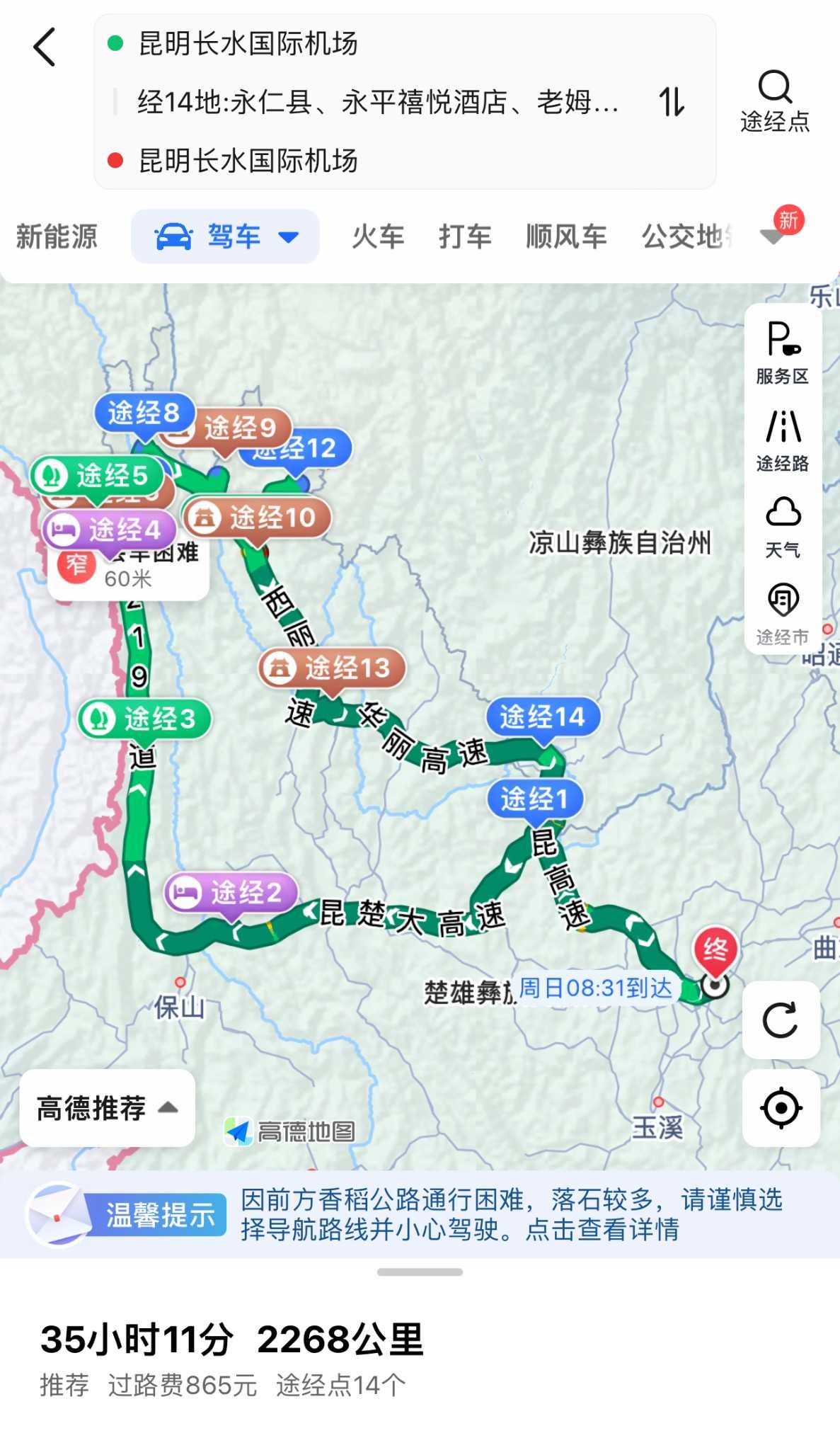
I had traveled the Beijing-Kunming Expressway from Kunming to Yongren many times before, with occasional rain along the way. After turning onto the Yongren-Jinshajiang Expressway, traffic was sparse, and tunnels became a common sight. The service areas were empty; lunch was a lonely affair. Once on the Kunming-Chuxiong Expressway, traffic increased but there was no congestion, and we arrived smoothly in Yongping county town. The hotel was in the city center, with amusement rides and stalls set up on the road in front—the staff said it was for the National Day celebrations, but the goods had a distinctly "Yiwu market" feel.
A four-kilometer drive brought me to Qudong Ancient Town. A vital commercial hub since ancient times, this place was known as the "Bonan Ancient Road" of the Southwest Silk Road and was also the site of the "Red and White Flag" massacre. Today, it stands as one of the few authentically preserved spots among Dali's tourist attractions. There was none of the clamor of Jiangnan water towns; most shops were shuttered. Horse tack hanging on the walls silently told of the bustling trade caravans that once passed through.
The town's mosque is somewhat famous, but it looked different from what I had imagined. Shaded by green trees, with students' artwork visible everywhere, the architecture resembled a Han Chinese temple more than anything else. I didn't see the legendary six marble-veneered square pillars or the green-glazed tiles. The main hall was built on a hillside, an easy climb, with two people praying inside. From the hilltop, Qudong town appeared quite large, with houses packed tightly together. As I descended, several elderly worshippers approached the mosque. One uncle gave a strange look to a woman scrolling on her phone while sitting on a chair—perhaps he had noticed her distinctive scarf.
The True Essence of Braised Chicken
In the alleyways, residents gathered for dinner, all eating braised chicken. Yongping's braised chicken is completely different from "braised chicken rice"—it's a standalone dish, not cooked together with rice. I hesitated at first because I don't particularly like braised chicken rice, but unable to find any other restaurant, I reluctantly ordered half a black-boned chicken, one catty and three taels (about 650 grams), costing 70 yuan, plus a small plate of cold vegetables. One bite and I understood why it's famous.
In the ancient town, many families were processing walnuts. Yongping is the hometown of walnuts; residents roast, crack, and pack them, charging three yuan per kilogram for the labor. I walked into one home where a couple was busy—the husband handling the roasting, the wife cracking walnuts. Judging by the house, years of hard work had earned them a comfortable home. A cat was curled up in a pile of walnuts, dozing lazily.
The Nujiang Canyon: Traveling Along National Highway 219
The Tiger Leaps on the Lancang River
After National Highway 219 was completed, the expressway from Baoshan to Lushui made traveling to the Lancang River and Gaoligong Mountain region much more convenient. I hope they never build an expressway from Lushui to Bingzhongluo—the national highway is already wide enough, with plenty of tunnels and little traffic, so why destroy the natural landscape? Passing by a natural "bath" and empty service areas, I exited the expressway at Lushui and continued along National Highway 219.
A colorful walkway built along the roadside stretches alongside the river valley, extending all the way to Bingzhongluo, 280 kilometers away. But locals almost never use it, and tourists wouldn't hike it either—after all, much of it passes through uninhabited wilderness, making the investment seem somewhat wasteful. Passing a viewpoint overlooking the surging Lancang River, I soon arrived at "Tiger Leaps" (Laohutiao). Similar to the Tiger Leaping Gorge, the drop creates rapid currents, but this spot is more primitive and requires no entrance fee. Giant boulders in the river resembled oversized Yuhua stones (rain-flower pebbles); some people climbed on them, even standing on massive rocks at the water's edge. Vendors sold bananas and large "rain-flower stones."
Laomudeng: A Village Above the Clouds
Continuing on, rain obscured the "Stone Moon," but zip lines across the river were occasionally visible. Twenty years ago, I had "flown" across a dry river valley at the First Pier of the Great Wall, a thrilling experience; now, I no longer have the courage for such adrenaline activities. I arrived at Laomudeng—a gentle slope at 1,800 meters above sea level, known as the "village above the clouds" for its frequent sea of clouds. "Looking up, a slit of sky; looking down, a ditch of a valley; going out relies on zip lines; farming is like rock climbing"—this was once the reality for the people of the Nujiang region.
Nestled against the Biluo Snow Mountain, Laomudeng faces the crown-shaped Crown Mountain across the valley. I parked by the roadside, ate some snacks for lunch, and then walked up the hill. Laomudeng Church is the largest Christian church in the Nujiang River basin, built with gray bricks and tiles, white walls, and red windows—simple, plain, solemn, and peaceful. But it was very small, the door was closed, and I couldn't see anything particularly special about it.
Zhiziluo: A "Ghost Town" Forgotten by Time
A four-kilometer drive brought me to Zhiziluo. In the Lisu language, the name means "good place." From the ancient Nanzhao Kingdom, people would cross the Biluo Snow Mountain here to reach the Gaoligong Mountains, and from there, enter Myanmar in a single day, making it an important post on the Tea Horse Road. After the founding of the People's Republic, it served as the seat of both the Nujiang Prefecture government and Bijiang County government, making it the most prosperous political and economic center of the Nujiang region. But because it was located on a mountainside with limited space for development, geological experts determined in 1974 that there was a significant risk of massive landslides. The prefecture government was moved down to Liuku, and in 1986, Bijiang County was abolished. Zhiziluo was reduced from a prefecture seat to a village, earning the names "Ghost Town" and "City of Memory."
More than forty years have passed, and the predicted landslide never occurred. Walking into Zhiziluo feels like stepping back into the 1970s and 1980s. The Octagonal Tower was a newly built library back then, but before a single book could be placed inside, it became an "abandoned building." Today, it houses the Nu Ethnic Museum, but the doors were locked. The adjacent sports field witnessed the sweat of countless young athletes. Soviet-era aesthetics and the marks of time cover every wall, with slogans visible everywhere. Climbing the Octagonal Tower to overlook the Nujiang Grand Canyon, I felt a sense of "ascending to a great height to behold the vastness between heaven and earth, the great river flowing endlessly away." The Nujiang River wound like a sheep's intestine, growing thinner as it stretched into the distance, eventually disappearing into the vast mountains. The Gaoligong Mountains raised their heads unyieldingly, while Crown Peak appeared and disappeared in the mist. A young man flew a drone from the rooftop—unfortunately, I hadn't brought mine.
Leaving Zhiziluo, passing through Fugong, I rested by a bridge. Buildings were covered in bold slogans. From a distance, I spotted two girls wearing ethnic costumes, a rare sight. Continuing toward Gongshan County, it was still rain and fog. That evening, I checked into a Super 8 Hotel—fortunately, I arrived in time, or there would have been no parking. Finding a restaurant in the rain wasn't easy; I finally settled on a Chongqing-style noodle shop. The owner, having worked in Chongqing for a long time, had lost his Yunnan accent.
Bingzhongluo: A Hidden Paradise Shared by Humans and Gods
The Great Bend of the Nujiang and Wuli Village
Morning brought more rain. Bingzhongluo is not far from Gongshan County—I chose to stay in Gongshan, which was cheaper and not far from Bingzhongluo. The hotel had a river-view room, but even after pulling back the curtains, I could barely see a sliver of the river—far from what I had imagined. After breakfast, I noticed the hotel was right next to a detention center, and a small incident occurred.
Passing a viewpoint where no one stopped—it seemed there was nothing to see—I stepped over the railing onto a walking path. A few more steps forward, and a beautiful view appeared. Most people had walked away disappointed, missing it entirely. Soon, I arrived at the Great Bend of the Nujiang. There's no need to crowd the viewing platform; 200 meters away, the view is even more expansive. Going around the mountain, Bingzhongluo came into view. Continuing further and turning to the other side of the mountain, another great bend of the Nujiang appeared, with a Peach Blossom Village above it.
I didn't queue to take a photo in front of the Bingzhongluo stone marker. Looking at Bingzhongluo town from a distance, then moving on to Wuli Village. Near the village entrance, traffic was backed up due to drivers ignoring road rules; it took half an hour to clear. While stuck, I gazed at Wuli Village from afar but didn't find it particularly beautiful—perhaps it was my perspective. Continuing to Qiunatong, this small village retained its primitive character, which is probably why city dwellers like it. But the scenery wasn't necessarily stunning. The village had just one road; some houses had large rain-flower stones displayed outside, presumably for sale. The folk houses were古朴 (rustic and simple), many built on stone slabs. Local children retained a朴实 (simple and unpretentious) manner, completely different from city kids. At the end of the road, there was a small church, but I couldn't enter.
Crossing the Biluo Snow Mountain: The Key Scare
Heading from Bingzhongluo toward Deqin, I first passed Stone Gate Pass—a scenic spot you can see in five minutes. Then came the crossing of the Biluo Snow Mountain. As altitude increased, rain and fog thickened, and high-altitude plants appeared, some trees draped in "beards." At a bend in the road, the roar of a rapid waterfall echoed through the mountains, accompanied by towering trees and nearby mist, creating an apocalyptic atmosphere. Soaking wet, I took photos, then returned to the car to start the engine. Reaching into my pocket, I realized—the car key was gone!
Panic set in. I searched the car once, then walked up and down the road several times, carefully checking the pavement and drainage ditches. Nothing. If the key was truly lost, stranded on this desolate mountain in the wilderness, I had no idea how I would survive. Finally, I resolved to search one more time, thoroughly. There, under the car seat cushion, I found it—a black key I had overlooked before. It must have slipped out of my pocket.
Passing through the Peacock Mountain Tunnel, I turned right and continued uphill. About 15 minutes later, I reached Peacock Mountain. Quite a few people had come, some camping, all hoping to glimpse the snow-capped mountain and lake. But today, nothing was visible—only when the mist occasionally drifted away could I see a small pond. Online descriptions call Peacock Mountain "the Switzerland of Yunnan," with scenery that changes beautifully through the seasons. Today, with all this swirling mist, it did have a certain fairy-tale quality.
Along the Lancang River: Desolation and Warmth
A Tibetan-Style Guesthouse in Xidang Village
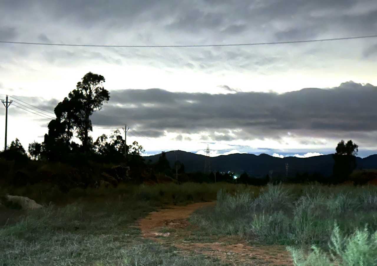
Returning to the main road, I descended all the way toward Deqin, the mist gradually clearing. Rivers flowed from the mountains into the distant Lancang River. Dropping to lower altitudes, the landscape transformed from lush greenery to a barren, lifeless dry river valley. Here, the Lancang River wasn't particularly majestic; the mountain slopes on both sides were steep and treacherous. To avoid the crowds in Deqin, I chose a Tibetan-style guesthouse in Xidang Village, Yunling Township—cheap and affordable. This area is also part of the Lancang River basin, with its yellow waters flowing through a barren valley, filled with a sense of desolation.
I checked into the guesthouse, where a young man was very helpful. He told me the guesthouse wasn't fully renovated yet, but because Deqin's accommodation capacity was saturated, local authorities had asked them to open early. Their family was a relocated household; everyone around them had been moved down from the mountains for centralized resettlement. His father had left the mountains years ago to do business in Shangri-La, saved up capital, and opened this guesthouse, relying on his own efforts. Most other villagers, however, lived on subsidies. On the mountain opposite, there were small caves where, during the civil war in the 1930s and 1940s, local Tibetans had hidden their treasures.
They had a large kitchen where guests could cook for themselves. We hurried to make dinner first, to avoid crowding with later arrivals. Over dinner, we chatted. He took the civil service exam every year, failing for four consecutive years. He knew that passing depended entirely on connections, but his parents still hoped he would find a stable job—I heard that civil servants in Deqin County earn over 10,000 yuan a month.
Baima Snow Mountain and the Great Bend of the Jinshajiang
The next morning, we were the last guests to leave the guesthouse. Others had either left early to see the "sunshine on golden mountain" at Feilai Temple (impossible in this weather) or had gone to hike from nearby Nilong Village to Yubeng. Before leaving, I asked the hostess why so many houses had red flags flying. She said each house with a flag had a Party member in it—and theirs was the only one without.
Leaving Yunling Township, I saw people hiking on the opposite mountain—that was the Yubeng trekking route. Nine years ago, I had come out of Yubeng on that very path; now the road was wider, with many sections paved in cement. Passing through Deqin County, I began crossing Baima Snow Mountain, still shrouded in mist and rain. After crossing the mountain, I rested at a simple viewpoint with many Mani stone piles. Soon, I arrived at the Great Bend of the Jinshajiang—nine years ago, you had to buy a Meili Snow Mountain combo ticket to see it; now it's open to everyone.
Balagezong: A Modern Legend of the Foolish Old Man Who Moved Mountains
The Story of Sinar Dingzhen
Balagezong is a well-developed scenic area, some distance from Shangri-La, requiring a 20-kilometer drive into the valley from the main road. Located at the junction of Yunnan, Sichuan, and Tibet, it's an important part of the "Three Parallel Rivers" UNESCO World Natural Heritage site in the Hongshan area. Legend has it that over 1,300 years ago, during the era of King Gesar, there was a brave and skilled Tibetan tribal chieftain named Sinar Dorje from Batang. His young and beautiful wife, Renchen Lhamo, grew tired of war and followed an old lama in search of a peaceful, isolated paradise. When Sinar Dorje learned of this, he abandoned his wealth, power, and territory, and, following his wife's footsteps, journeyed south from Batang to settle in Bala. From then on, the prominent Batang family disappeared, and at the foot of the snow-capped mountain at the end of the Balagezong Canyon, a peaceful village emerged—Bala Village.
The founder of this scenic area is Sinar Dingzhen. Blind in one eye from a childhood blacksmithing accident, he once appeared on CCTV's "The Reader" program, sharing his story of leaving the mountain village, returning, selling off his family assets to build a road, and ultimately leading the villagers out of the mountains. This unique experience made Balagezong famous. The parking lot was huge; the entrance fee plus shuttle bus cost 170 yuan, with an additional 70 yuan to visit the Stupa.
The Canyon, the Stupa, and the Echo Wall
The scenic area bus carried tourists up the winding mountain road, playing introductions to the attractions and Sinar Dingzhen's "Reader" content. Half an hour later, we arrived at Bala Village—though most of the buildings were newly constructed. "Bala" comes from a Tibetan transliteration, meaning a Tibetan village that migrated from Batang. Today, it has become a center for folk culture experiences. I flew my drone, looking at the road carved through the towering mountains, and couldn't help but feel this was truly a modern version of the Foolish Old Man Who Moved Mountains.

The weather was bad, so I gave up on the Shangri-La Stupa. The Echo Wall, called "Shi Sha An Dong" in Tibetan, is the first petal on the east side of the Eight-Petal Lotus. Shouting loudly toward the cliff face, the sound waves reflect back, echoing layer upon layer in your ears. The 48-second, 800-meter-high world's highest zip line is a favorite among young people, their screams echoing through the valley. Walking on the glass-bottomed walkway, with a vertical drop of 700 meters, mist drifting beneath your feet—some people get scared.
Photography was not allowed inside the Tibetan Cultural Exhibition Center (Bala Drolma Lhakhang). Drolma Lhakhang is a Guanyin (Avalokiteshvara) temple built over 1,300 years ago by the chieftain Sinar Dorje behind his Dayong residence. Due to its age, it was rebuilt on the site of the original 21-Tara hall. The temple houses 21 Taras, a group of goddesses who deliver and save beings from suffering. Outside is the Dayong Stupa complex, consisting of eight white stupas, respectively enshrining the most representative figures of Tibetan Buddhism: Shakyamuni Buddha, Guru Rinpoche (Padmasambhava), Amitayus (Long-Life Buddha), Four-Armed Avalokiteshvara, Manjushri, Yellow Jambhala (God of Wealth), Ushnishavijaya, and Tara—representing the eight auspicious symbols of Tibet.
Finally, I reached the Grand Canyon scenic area. Some people were rafting; I only walked a few hundred meters on the boardwalk before turning back—from what I could see, the scenery probably didn't change much further in.
Shangri-La: Napahai Lake and Dukezong
Night in Dukezong Ancient Town
Leaving Balagezong, I paused briefly by a river in the valley to watch the stream. Heading toward Shangri-La, the sky gradually darkened, and a rare patch of blue sky appeared. Just before darkness fell, I caught a glimpse of Napahai Lake from a high vantage point. There were quite a few cars entering Shangri-La, and with the rain, some traffic congestion. I had booked a guesthouse in Dukezong Ancient Town, and finding a parking spot took a while.
Dinner was at a Sichuan restaurant recommended by the guesthouse owner. The owner's family were all Sichuanese, and the food was authentic—many Sichuanese people were eating there. At night, Dukezong Ancient Town was lively. Even in the rain, crowds of young people were eating, drinking, and having fun. Many wore traditional costumes; others lined up in the square to pray at the largest prayer wheel. Young people were letting off steam here.
Napahai Lake: An Oil Painting in the Rain
In the morning, after breakfast at the Sichuan restaurant, I headed to Napahai Lake. The area was mostly open; you could drive along the lakeside road, stopping to look as you went. At first, the navigation led me to a blocked road; after turning back, I reached the lakeshore. Many people were horse riding—I had ridden horses in Hongyuan years ago and found it very uncomfortable. Near the lake were wetlands and marshes. I drove slowly, stopping frequently. Napahai in the rain was gray, but the scenery was still beautiful, with cattle and horses living leisurely. The grasslands here looked like oil paintings, rich in color.
Conclusion: The Gift of the Three Parallel Rivers
This 2,300-kilometer journey, starting from Kunming, crossed the Nujiang, Lancangjiang, and Jinshajiang rivers, traversed the Biluo Snow Mountain and Baima Snow Mountain, and passed through canyons, ancient towns, ghost towns, and hidden paradises. It was not just a geographical crossing, but a journey back in time—from the Tea Horse Road of the ancient Nanzhao Kingdom, to the City of Memory frozen in the 1970s and 1980s, to the modern legend of the Foolish Old Man Who Moved Mountains. Where the three rivers flow in parallel, nature and humanity intertwine, desolation and warmth coexist.
Practical Tips: - During National Day, expressways are toll-free and accommodation is affordable (100–300 yuan/night) - Rent a car from platforms like "Cheyou Tianxia"; pickup is convenient - Primarily mountain roads; drive carefully, especially in rain and fog - Yongping braised chicken is worth trying—completely different from "braised chicken rice" - Balagezong scenic area is large; set aside at least half a day - Dukezong Ancient Town in Shangri-La is lively at night, great for experiencing local culture
The highlights of this journey weren't specific scenic spots, but those unexpected encounters—the cat in the walnut pile, the figures on the Yubeng hiking trail, the guesthouse young man's civil service dream, the houses flying red flags... They made this crossing of the three rivers a shining footnote in the story of a life.
You should also read:
Into the Hidden Valley: A Solo Journey Through the Mysterious Dulong River
Into the Hidden Valley: A Solo Journey Through the Mysterious Dulong River Deep in the northwestern corner of Yunnan Province, tucked away from the modern world, lies a place that feels like a secret whispered among mountains. The Dulong River Valley is not just a…
Continue reading...
God’s Abandoned Palette: A Self-Drive Journey Through Yunnan’s Dongchuan Red Land
God’s Abandoned Palette: A Self-Drive Journey Through Yunnan’s Dongchuan Red Land Travel has never been about reaching some distant geographic coordinate. It’s about encountering, along the way, the version of yourself buried beneath the rubble of daily routine. During this May Day holiday, I finally…
Continue reading...
Two Girls' Graduation Trip: Dali and Shuanglang – A Poetic Farewell to Mountains and Sea
Two Girls' Graduation Trip: Dali and Shuanglang – A Poetic Farewell to Mountains and Sea Preface: Catching the Tail of Youth, Heading South During our senior year of college, my roommate and I – two girls studying in Beijing – decided to bid farewell to…
Continue reading...